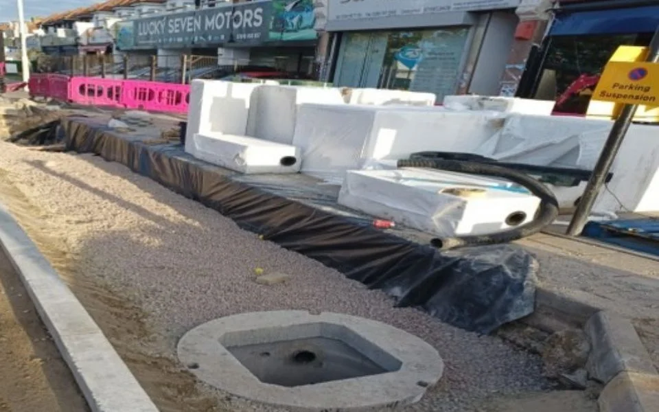

Underground rainwater storage is now in under High Road, Seven Kings, Claybury Broadway and Tomswood Hill. Which streets got it, and how to report a flood.
Three Redbridge roads that have flooded before now have underground rainwater storage beneath them. Redbridge Council has finished installing Hydrorock blocks under High Road in Seven Kings, Claybury Broadway in Clayhall and Tomswood Hill in Barkingside.
The council announced the work on 13 October. It said all three sites were chosen because of previous episodes of flooding.
How it works
The council describes Hydrorock as “a giant underground sponge” laid beneath the road. In a heavy downpour it soaks up rainwater and holds it, then lets it drain slowly into the sewers. The aim is to stop a sudden surge of surface water from overwhelming the drains, which the council calls one of the main causes of road flooding.
Sections of road above the blocks were also resurfaced with permeable paving, so rain can soak through to the storage below.
The council says the schemes installed this year can hold around 426,000 litres of storm water at once. Across every flood scheme it has built so far, the borough can now hold more than 2.2 million litres. Both figures are from the same release.
Six rain gardens as well
The same programme planted six rain gardens, which are planted beds that slow rainwater before it reaches the drains. The council’s release names:
- Stonely Road, Clayhall
- Harewood Drive, Clayhall
- Knighton Drive, off Monkhams Lane, Woodford
- Knighton Close, off Monkhams Lane, Woodford
- Forest Road, off Monkhams Lane, Woodford
- Addison Road, Hainault
The council’s own flood programme page has not caught up. On 15 October it still listed the Monkhams Lane works as in progress and a rain garden on Stoneleigh Road as due to start. It spells the Monkhams street Forest Drive, not Forest Road.
That page also lists Hydrorock already laid under parking bays on Hermon Hill and Wellesley Road in Wanstead, plus completed rain gardens at:
- Henley Road and Mortlake Road
- Cherry Tree Rise and Buckhurst Road
- Dawlish Drive and South Park Road
The council puts the whole programme within an £11 million, ten-year investment plan for flood defences.
Why these streets
The storm of 25 July 2021 is the flood most people here remember. The council’s Section 19 investigation into it, published in September 2022, counted the reports it received.
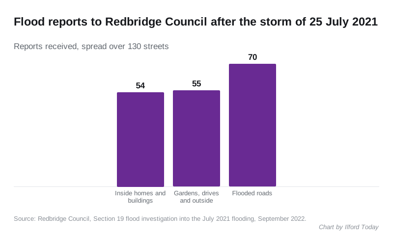
The report counted 54 reports of flooding inside properties, 55 of flooding outside and 70 of flooded roads, spread over 130 streets. A rest centre opened at Sir James Hawkey Hall in Woodford Green that Sunday. It was not needed and closed the next day.
The report called Clayhall “one of the areas which was most impacted”. It names Claybury Broadway and Stoneleigh Road among the Clayhall streets where homes reported flooding inside. Residents there said the gullies were surcharging, meaning they were pushing water back up because the sewers were full.
What it means for you
If you live on or near these roads, heavy rain should drain away more slowly and more steadily than before. The council does not claim this ends flooding. In its earlier case study on drainage schemes, Cllr Jo Blackman, the cabinet member responsible, said: “We may not be able to prevent all future flooding incidents.”
What you can do:
- Report a flood or a blocked gully to the council on its reporting page. Repeat reports from one street are part of how hotspots get picked.
- Read the flood advice on preparing a home and what to do after a flood, on the council’s flood advice page.
- Check the plans for your area. The council’s flood strategies and reports include the 2024 Surface Water Management Plan, which has a street-level map.
The council says more work has been earmarked under its Flood Risk Management Strategy and Surface Water Management Plan. It has not yet said which streets are next.
For road closures while works like these are under way, see our Ilford roadworks page.
Sources
- Redbridge Council, Hydrorock release, 13 October 2026
- Redbridge Council, Reducing flood risk: case studies and the 2025/26 flood alleviation programme
- Redbridge Council, Section 19 report on the July 2021 flooding, September 2022
Have your say